Viewing entries in
MSc Alumni

Nicola Houtman

Nicola.jpg

Nicola Houtman

Contact: nicolahoutman@gmail.com

MSc Geography, University of Victoria

BSc Geography, University of Victoria

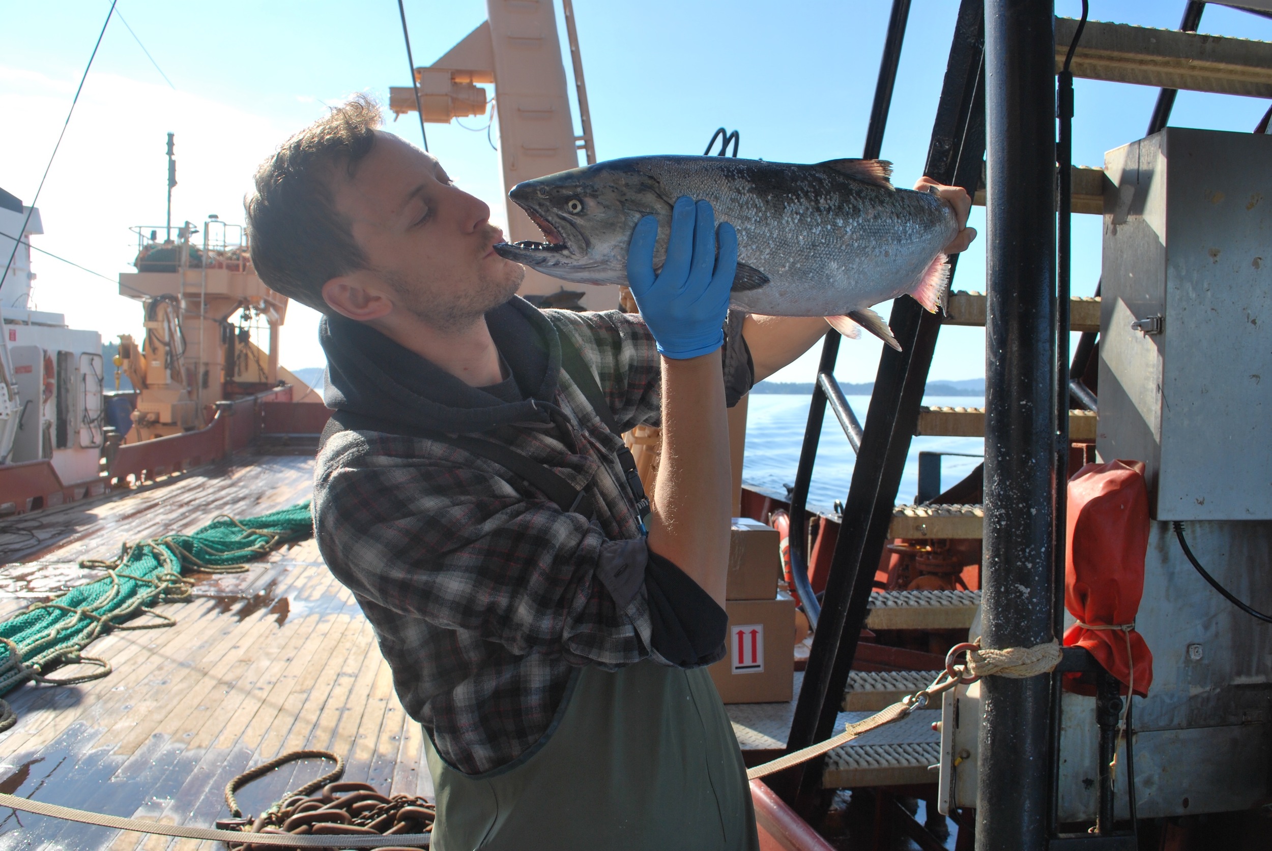
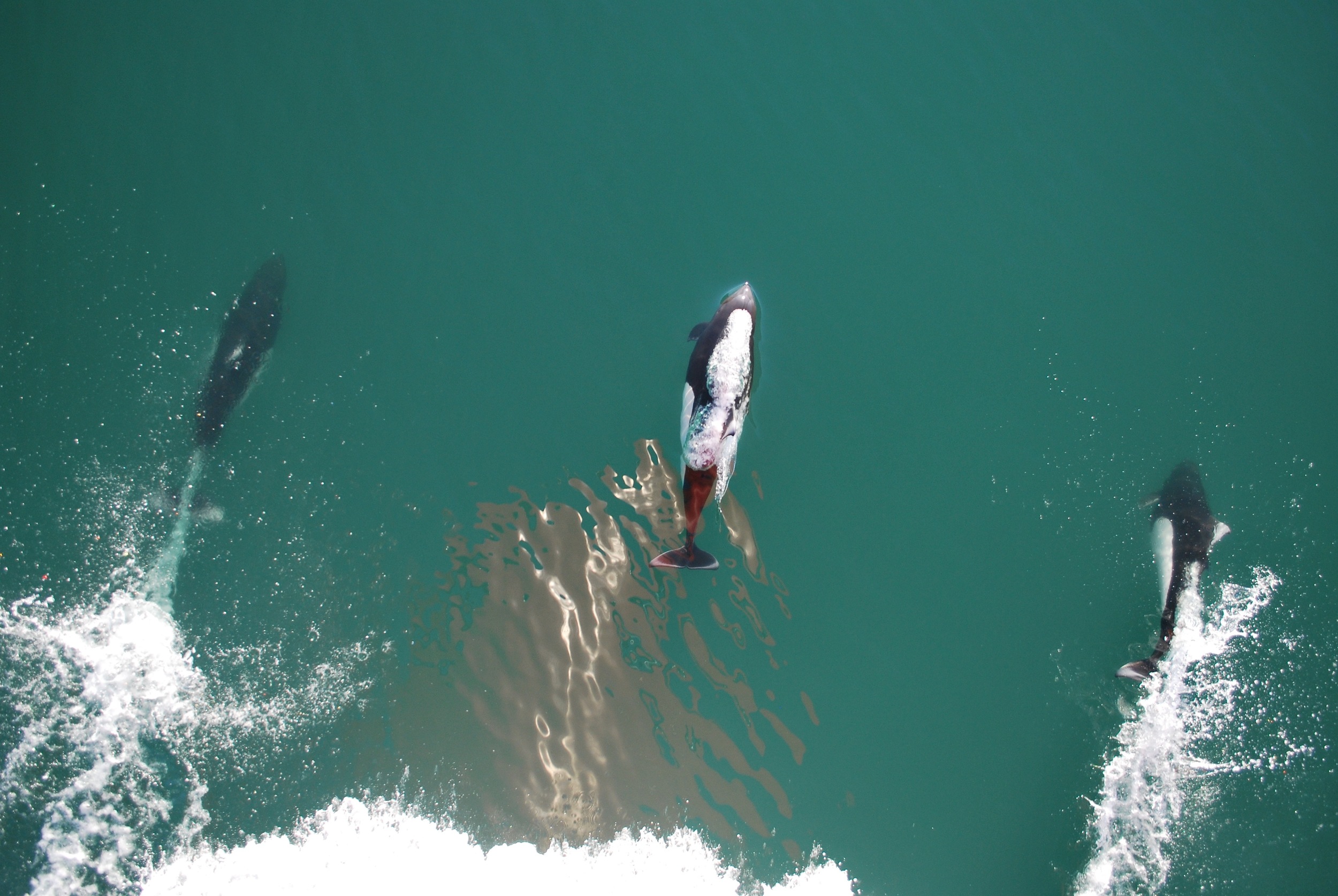
Nicola Houtman is a Master’s candidate interested in mapping important forage fish species in the Strait of Georgia in order to learn about important areas for conservation for their endangered predators (Chinook and marbled murrelets). The ecology and distribution of many of British Columbia’s forage fish are undocumented due to limited fisheries targeting forage fish, the focus on species or stock specific management rather than ecosystem-based management, and the highly mobile or migratory life history of forage fish species. In particular, the distribution of pelagic (i.e. water column) foraging habitats of forage fish is virtually undocumented for Pacific sand lance (Ammodytes personatus), Northern anchovy (Engraulis mordax), and surf smelt (Hypomensus pretiosus).

The main research goal of this project is to map forage fish distributions in pelagic habitats in the Strait of Georgia. The project will be accomplished by:

1) Creating species distribution models that can predict the locations of Pacific sand lance, surf smelt, and Northern anchovy (three key forage species with little distribution data).

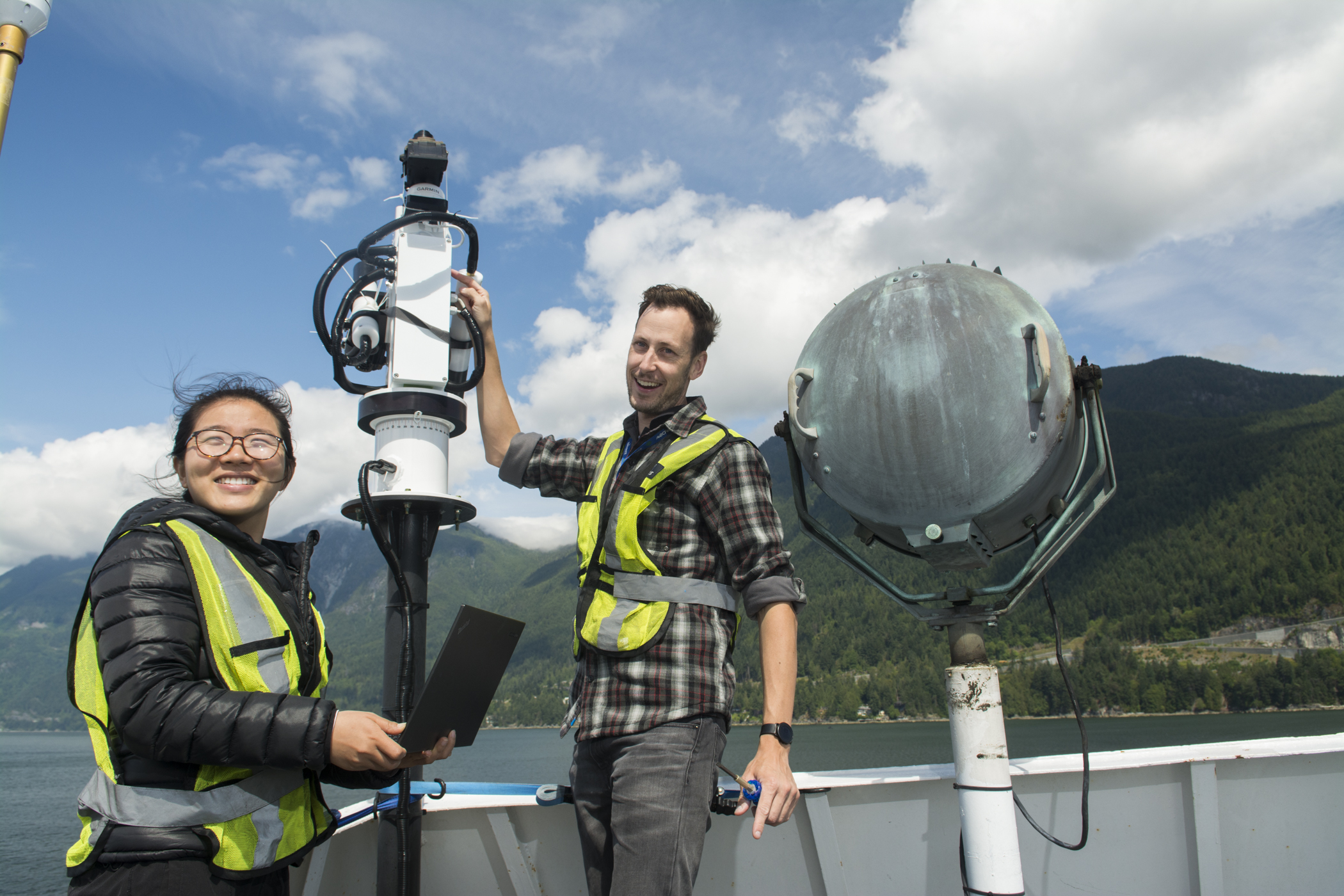
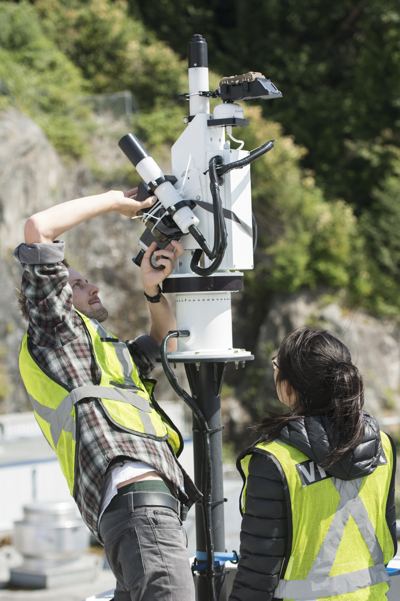
2) Developing a methodology for using remotely piloted aircrafts (RPAs, i.e. unmanned aerial vehicles or drones) to map schools of forage fish in the field, and identify species and school metrics (e.g., average fish size, school size). 

3) Visiting the areas predicted as high and low probability of fish presence by the models and using the RPA methodology I develop to ground-truth the models (i.e. try to find fish). 


This project is in collaboration with Project Watershed, Parks Canada, and the Department of Fisheries and Oceans. 

 
DFO.png

Lianna Gendall

lianna_1.jpg

Lianna Gendall

MSc Geography, University of Victoria
BSc Biology, University of Alberta      
Contact

Lianna Gendall is a Master’s candidate with interests in kelp forest ecology, ecosystem-based management and the use of remote sensing to answer important ecological questions. Kelp forests are some of the most diverse and productive habitats on earth and provide many important ecosystem services to humans. Lianna’s research is focused on creating a baseline map of kelp forest distributions along the coast of Haida Gwaii and exploring environmental drivers of change in these ecosystems. This project is a collaborative effort between the SPECTRAL remote sensing laboratory, the Hakai Institute and the Marine Plan Partnership for the North Pacific Coast (MaPP) and will help to improve management strategies for kelp forest ecosystems in the future.

Lianna has a Bachelor’s degree in Animal Biology from the University of Alberta. Throughout her degree, Lianna’s curiosity and love for the ocean grew while working as a research assistant and Dive Master on several international marine research bases.  She spent the last semester of her BSc. at Bamfield Marine Sciences Centre, where she fell in love with the complex and beautiful temperate ecosystems of the west coast of Canada.  Since graduating, she has worked as a coral reef ecology instructor in Mexico and with the Salmon Coded Wire Tag Laboratory of J.O. Thomas & Associated Ltd. All of these experiences have solidified her desire to identify and monitor long-term change in coastal marine ecosystems and she is excited for the new experiences and challenges that lie ahead. 

Click HERE to learn more about Lianna’s Project

Brian Timmer

shark.jpg

MSc Geography    
BSc Biology       
Contact: briantimmer@uvic.ca | twitter: @Scuba_Timmer |   

Brian’s MSc was focused on quantifying uncertainties of kelp bed metrics associated with changes in tidal height and current, as detected by remote sensing. Brian used data from in situ hyperspectral radiometers, multispectral UAV, high-resolution WorldView imagery, and supplementary data acquired from established Hakai kelp monitoring sites near Calvert Island to complete his thesis.

Click Here to learn more about Brian’s project.


Andrea Hilborn

MSc Student

MSc in Geography
BSc Major in Geography, Minor in Mathematics (University of Victoria)
Contact

Research Areas:
ocean colour remote sensing, atmospheric corrections, multi-satellite time series, geospatial analysis

Thesis Project:
My master's project extends the local atmospheric correction from MODIS Aqua to the Suomi-NPP VIIRS sensor in order to identify phytoplankton bloom phenology throughout the Salish Sea. 

We are excited to have partnerships with the Pacific Salmon Foundation, MITACS and MEOPAR to help make this possible!

Publications and Presentations:

Contributor: Geomorphic and geologic controls of geohazards induced by Nepal’s 2015 Gorkha earthquakeScience 2015.

Affiliations:

Mitacs
MEOPAR
Pacific Salmon Foundation
Salish Sea Marine Survival Project
Ocean Networks Canada
Science Venture, University of Victoria
University of Victoria Campus Community Garden

Stephen Phillips

Project Coordinator, MSc Alumni

Project Coordinator
MSc. Geography
BSc. Geography
BSc. Physics

ContactMSc. Thesis | LinkedIn

Research Areas: remote sensing, ocean colour, algorithm development, optical equipment, spatial analysis, ocean dynamics.

Research Projects:

Salish Sea:  My graduate research project looked at the spatio-temporal optical and biogeochemical dynamics of the Salish Sea on the west coast of Canada.  Using an optical classification method I sub-regionalized the optical properties of this coastal region and used this information to parameterize satellite chlorophyll-a models with improved accuracy.  My project focused on the MODIS-Aqua and Sentinel-3 ocean colour sensors.  This outcomes of my research were to provide more accurate remotely sensed Chlorophyll-a data for an ecosystem based approach to effectively monitor the health of the Salish Sea.   

Amazon:  In the fall of 2014 I had the opportunity to be a project coordinator and researcher on the Cruizeiro do Sul, Research Cruise in Belém, Brazil.  This project focused on understanding the optical dynamics of the Amazon River Plume as it migrates out into the tropical Atlantic.  Using similar optical instrumentation and methods developed in the Salish Sea this was a great opportunity to apply and test my research in a new oceanic environment.  

FOCOS:  Ferry Ocean Colour Observation Systems (Current Project).  I'm currently involved with a new project that builds on my research with two permanent ocean colour monitoring stations installed on two ships of opportunity.  Through various partnerships this project will see two fully automated radiometric ocean colour instruments installed on two BC Ferries, one of which is now in operation.  In conjunction with Ocean Networks Canada this project presents a unique opportunity to combine resources and provide valuable and accurate ocean colour data that will be used to better understand the health of our coastal ecosystem.  As lead project coordinator I'm responsible for the successful deployment of these new systems, which are the first of their kind to go into full time operation in Canada.  

Yuyan Yang

Lab Assistant, MSc Student

MSc Student in statistics  

Research:

Yuyan's project focused on acquiring data from the BC ferries using citizens for science as part of the FOCOS project.  She used this information to statistically compare and test the data for accuracy.

Nathan Vandenberg

Lab Assistant, MSc Student

MSc in Computer Science

Research:

Nathan has a background in databases, data mining, and machine learning.  For his thesis, Nathan worked on a program that processes data from optical instruments and tablets installed on the BC ferries as part of the FOCOS program.  His integral role in this program ensured that data was cleaned for quality control and output into a format that was useful for further analysis. 

Nick Komick

MSc Alumni

MSc Geography

Research:
The focus of my research was a temporal and spatial analysis of chl in the Strait of Georgia.  To perform this analysis, imagery from MODIS was employed.  An intermediate step included producing a set of algorithms adapted specifically to the conditions in the coastal waters of the SoG. This allows a better understanding of relationships, triggers, and constraints in both space and time between chl and suspended sediment concentrations.  Identifying these temporal and spatial properties is important in a more complete understanding of the ecosystem in the SoG.

Laurie Gallagher

MSc Alumni

MSc Geography

Laurie's thesis project evaluated the use of remote sensing to retrieve the optical and geochemical properties of inland and coastal waters. Traditionally, water quality sampling involves in-situ measurements as well as the collection of water samples for subsequent laboratory analysis. These methods are time intensive and expensive and do not provide a spatial or temporal view of water quality. The use of remote sensing provides the potential for less expensive analysis of water quality and allows an evaluation of the spatial and temporal distribution of water components using aircraft-based and/or satellite-based sensors


Christiaan Piller

MSc Alumni

MSc Geography

Optical remote detection of surface water quality for open ocean waters has been ongoing since the 1960’s.  This method of detection is much more challenging and not yet standard practice for the more optically complex inland and coastal waters.  My research project dealt with the investigation of the potential application of airborne hyperspectral sensors to detect water quality in the Cowichan watershed, on Vancouver Island, BC.  Lake Cowichan and Cowichan Bay, both apart of the watershed, have been examined as the inlands and coastal water bodies, respectively.