

Current Projects
Current Projects:
Current Projects
Current Projects:
Our goal is to facilitate the use of satellite and other remote sensing systems by developing bio-optical models to effectively identify and quantify constituents in coastal and riverine waters. Ultimately, this will improve our spatial-temporal understanding of the impacts of forestry, agriculture, aquaculture, pollution, and climate change in these waters.
We are currently researching the optical water properties and biochemistry of inland and coastal waters of Vancouver Island and the Salish Sea, Canada. We use a set of field optical sensors to measure attenuation, absorption, upwelling and downwelling radiation, fluorescence, etc. These sensors detect light in fine spatial and spectral resolutions. We also work with airborne (casi), satellite (Hyperion) hyperspectral, and satellite multispectral (Sentinel-3, MODIS, VIIRS, SeaWifs) imagery.
Below is a summary of our current and past projects. Click each one to learn more!


BC ocean productivity bioregionalization and drivers of change

Assisting fisheries management by integration of data from non-specialized assets, ferries, citizens, and satellites

Ferry
Ocean Colour
Observation Systems
We use satellites, sensors aboard BC Ferries, and passengers to collect data to quantify the health of our coastal waters. This can largely affect Pacific Salmon populations, which have been declining in the past decades.
To help fisheries managers understand the health of our fish stocks we are using tablets and passengers to collect more information on the health of the ocean, or productivity.


Spatio-temporal analysis of the chlorophyll using satellite imagery of the Salish Sea
This portion of the project will look at the Salish Sea from space through satellite images to retrieve spatio-temporal chlorophyll concentrations of the Salish Sea. This involves developing a region-specific atmospheric correction algorithm to remove the interference of the atmosphere and increase the accuracy of the data coverage. This results of this work will provide a reliable time series to analyze the long term trends in the Salish Sea.


Synchrony between phytoplankton and zooplankton phenology in the Salish Sea
This project looks at long-term spatial data of phytoplankton and zooplankton to identify their response to different climate drivers (e.g. SST, wind) and global climatic indices. This will provide insight into their influence on the growth, survival, and overall return strength of salmon populations in the Salish Sea. This project will allow us to contribute to one of the primary objectives of the Salish Sea Marine Survival Project (SSMSP), led by the Pacific Salmon Foundation (PSF), which is to assess whether the “bottom-up processes driven by annual environmental conditions are the primary determinate of salmon production via early marine survival.”


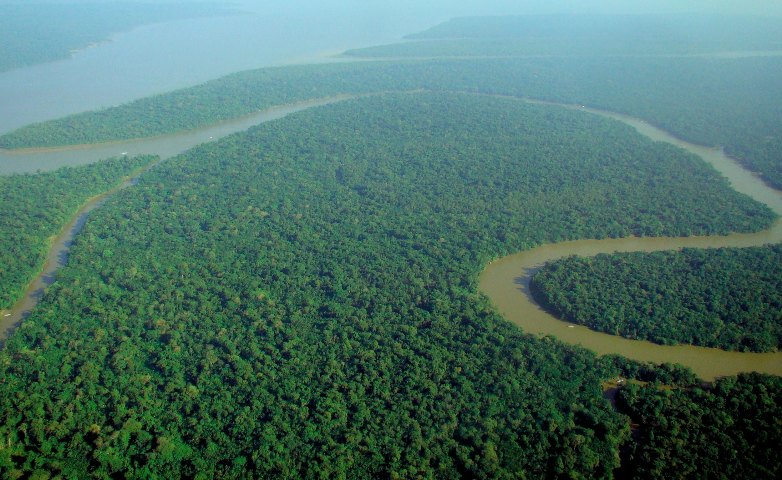
Modelling the Light Field in the Waters of the Equatorial Atlantic Under the Effects of the Amazon River Discharge
Due to high sediment loads produced by the Amazon River discharge there are light constraints for primary production in the waters of the Equatorial Atlantic. The goal of this project is to define over time the horizontal and vertical structure of the light field and biogeochemical variables in these waters. To accomplish this two surveys were conducted in the Equatorial Atlantic under the influence of the Amazon River plume to measure in situ water optical properties and biochemical compounds to characterize the variability.
Past Projects
Past Projects:
Past Projects
Past Projects:

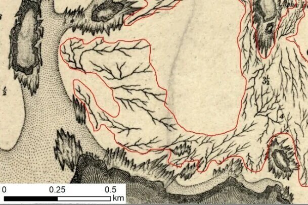
Spatial Temporal Distribution of Nereocystis Luetkeana (Bull Kelp) and use by Juvenile Salmonids in the Salish Sea
Kelp, specifically Nereocystic luekeana (bull kelp), form extensive forests in rocky habitats along the subtidal zone of the coast of British Columbia. These kelp forests provide important habitat for juvenile salmon attracting their preferred food and providing protection from predators. In alignment with the Salish Sea Marine Survival Project this research is looking at defining the surface extent of bull kelp beds using satellite imagery associated with sea-kayak surveys for several regions in the Gulf Islands National Reserve and in the Comox and Cowichan estuaries in collaboration with several environmental stewardship community organizations and First Nation groups.


Long-Term Aerial Photographic Mapping of Eelgrass (Zostera marina) in the Salish Sea (1932 - 2016)

As part of the Salish Sea Marine Survival Project this research explores the use of Unmanned Aerial Vehicles (UAVs) to deliver high resolution, affordable aerial photography for local-scale eelgrass (Zostera marina) mapping projects and explores photo-interpretive and digital mapping methodologies for delineating eelgrass distribution. Along modern UAV imagery this project uses archived historic aerial photography (1932-2014) to map historic eelgrass distribution and assess: changes of aerial extent, shape and edge characteristics, potential impacts of shoreline and watershed alterations, and priority sites for conservation and restoration. Link to thesis and publications ( 1 ) ( 2 ).


Analysis of MODIS-Aqua imagery to determine spring phytoplankton phenology in the Strait of Georgia, Canada
The goal of this research was to construct a time series of accurate chlorophyll-a concentration for the Strait of Georgia, Canada, using an improved atmospheric correction scheme and workflow for the MODIS-Aqua satellite instrument to describe the chla dynamics and spring bloom phenology in the SoG. In situ radiometric samples were acquired to assess three potential atmospheric correction schemes. Water property samples were collected to further assess atmospheric corrections and the applied ‘Ocean Color 3 Modis’ (OC3M) standard chlorophyll algorithm. Link to thesis and publication.
Bio-optical Characterization of the Salish Sea, Canada, Towards Improved Chlorophyll Algorithms for MODIS and Sentinel-3
The goal of this research was to improve ocean colour chlorophyll retrievals in the Salish Sea by characterizing the main drivers of optical variability and using this information to parameterize empirical algorithms. This was accomplished through 5 field cruises with the Department of Fisheries and Oceans and bi-weekly trips on an instrumented BC Ferry to collect in situ water and optical measurements. The optical variability was then characterized through a hierarchical analysis and statistically compared to the biogeochemical data to define specific classes or bio-optical regimes in the Salish Sea. Link to the thesis.


Spatial and temporal particulate variability at an integrated multi-trophic aquaculture (IMTA) site in Kyuquot Sound
The goal of this research was to detail spatial and temporal organic particulate dynamics at an integrated IMTA site on the west coast of Vancouver Island, Canada. In-situ optical measurements were collected in conjunction with water samples for particulate organic carbon and chlorophyll concentrations. These measurements were performed over three seasons (autumn, winter and summer) at reference sites and at sites within and directly adjacent to the fish component of the IMTA system. Data were examined to examine the bio-optical relationships over various timescales (seasonally, daily, and within day) to describe the particulate variability and to assess the effectiveness of bio-optical methods for environmental monitoring.
Link to thesis. Also see the Publication.
Eelgrass spectral detection and remote sensing mapping
Eelgrass (Zostera marina) is a keystone component of inter and sub-tidal ecosystems. Delineation and continuous monitoring of eelgrass distribution is an integral part of understanding these pressures and providing effective coastal ecosystem management. A proposed tool for such spatial monitoring is remote imagery, which can cost and time effectively cover large and inaccessible areas frequently. In this study, in situ hyperspectral measurements were used to define key spectral variables that provide the greatest spectral separation between Zostera marina and associated shallow submerged substrates. Link to thesis.

Spatial and temporal analysis of water siltation caused by artisanal small-scale gold mining in the Tapajós water basin, Brazillian Amazon: an optics and remote sensing approach
The main goal of this research was to investigate the spatial and temporal impacts of water siltation caused by Artisanal Small-scale Gold Mining (ASGM) on the underwater light field of the Tapajós River and its main tributaries (Jamanxim, Novo, Tocantinzinho, and Crepori rivers). In order to accomplish this, two fieldwork research trips were undertaken to collect data associated with water quality and radiometric data. This data provided information to quantify the underwater light field in water affected by a gradient of mining tailings intensity. Link to thesis and publication.
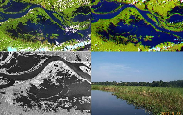
Synergistic use of Radarsat-2 and TerraSAR-X to the monitoring of vegetation distribution, growth and phenology in the Amazon floodplain wetlands
This research project looked at the quantification of vegetation dynamics and variability in the Amazon floodplain, through the synergistic use of Radarsat 2 and TerraSAR-X systems. The main objectives were to develop an operational, accurate method for macrophyte and woody vegetation cover mapping and monitoring in the Amazon floodplain environment. Link to thesis.

Transmission of light through the water column and remote sensing reflectance of the Amazon River and main tributaries and mine impacted rivers
The characterization of transmission of solar energy in the water column is essential for understanding several water processes such as phytoplankton distribution and primary productivity, the ecology, and chemistry of the upper water column. Changes in transmission of light in water are mostly due to variability of water optical constituents, which in the Amazon are strongly affected by seasonal riverine stream flow, regional geology, and upland processes. Anthropogenic use of the Amazonian uplands could have major regional effects on the seasonal distribution of optical constituents in the water, and subsequently affect the quantity and quality of light in the water column.
Defining spatial-temporal flooding dynamics and land cover in the Brazilian Pantanal wetland using satellite imagery to define habitat connectivity for the Pantanal marsh deer
The Pantanal is the world’s largest continental tropical wetland located between Brazil, Paraguay, and Bolivia. The Paraguay River, its tributaries, and the rainfall patterns of the region, support an annual flood regime that varies both temporally and spatially, and helps define the geomorphology and the large biodiversity of the region. However, the Pantanal and its rich biodiversity are vulnerable to anthropogenic disturbances. The human-altered landscape plays a role on patterns of resource selection and connectivity of the landscape for certain species, specifically the Pantanal marsh deer (Blastocerus dichotomus). The goal of this project was to derive spatial temporal flooding and land cover maps of the entire Brazilian Pantanal, and integrate this information to define landscape connectivity and resource availability for the Pantanal marsh deer.
