Coastal oceans are highly dynamic, and of great biogeochemical, ecological, and economic importance, thus requiring increasing monitoring and management. In the Salish Sea, the interannual productivity variability is suggested to contribute to the large variability in the Pacific salmon populations in the past 50 years, which have exhibited a general decline in the past decades. This has led to considerable uncertainties in the Department of Fisheries and Oceans (DFO) current forecast models. Fundamental to the improvement of forecast return models is data with sufficient time and spatial resolutions to address the dynamics of the environment; current research cruises are not effective in observing the Salish Sea at the required resolution. Data collected by satellites, sensors aboard ships of opportunity, and citizens are complementary and, together with data from research cruises, provide information at the needed scales to assist in fisheries management.
Water quality in the ocean has a lot to do with the health of the ocean, or productivity. This can largely affect Pacific Salmon populations, which have been declining in the past decades. To help fisheries managers understand the health of our fish stocks we need to collect more information on the health of the ocean.


We use satellites, sensors aboard BC Ferries, and passengers to collect data to quantify the health of our coastal waters.
Goals
The acquisition and integration of spatial-temporal environmental data to assist in fisheries management in the Salish Sea is addressed in this research according to the following objectives:
01. Acquire validated and accurately tested spatial-temporal environmental data using non-specialized assets: ferries, citizens, and satellites
02. Investigate the level of synchrony between primary productivity (from Objective 1) and salmon productivity as an initial step toward integration of environmental data on salmon forecast models by DFO.
Outcomes from this project are: a framework to engage the marine community, citizens, government, industry, and scientists, in taking advantage of non-specialized assets to fulfill the needs of marine observation data in the face of limited availability of specialized resources, such as research vessels; from that, contribute to the decision-making in fisheries management; training of HQP with interdisciplinary knowledge in community engagement, ocean sciences, technology, and resource management to be future innovators; providing end-users economic opportunities to expand sales and to enrich and improve their social and environmental outreach initiatives; providing end-users with spatial-temporal environmental information and associated analysis with salmon stock assessment to advise on implementation of salmon forecast return models.
Methods
To address these objectives, we built a multidisciplinary group of partners in academia (UVic, Dal, Laval), government (DFO, Parks Canada), ocean-related industry (BC Ferries, Satlantic), and non-governmental organizations (Pacific Salmon Foundation-PSF, Ocean Networks Canada-ONC), and communities (ferry passengers and fishermen), with expertise in ocean science and remote sensing, computer science, statistics, fisheries management, fisheries biology, community engagement, geography, local knowledge, and engineering.
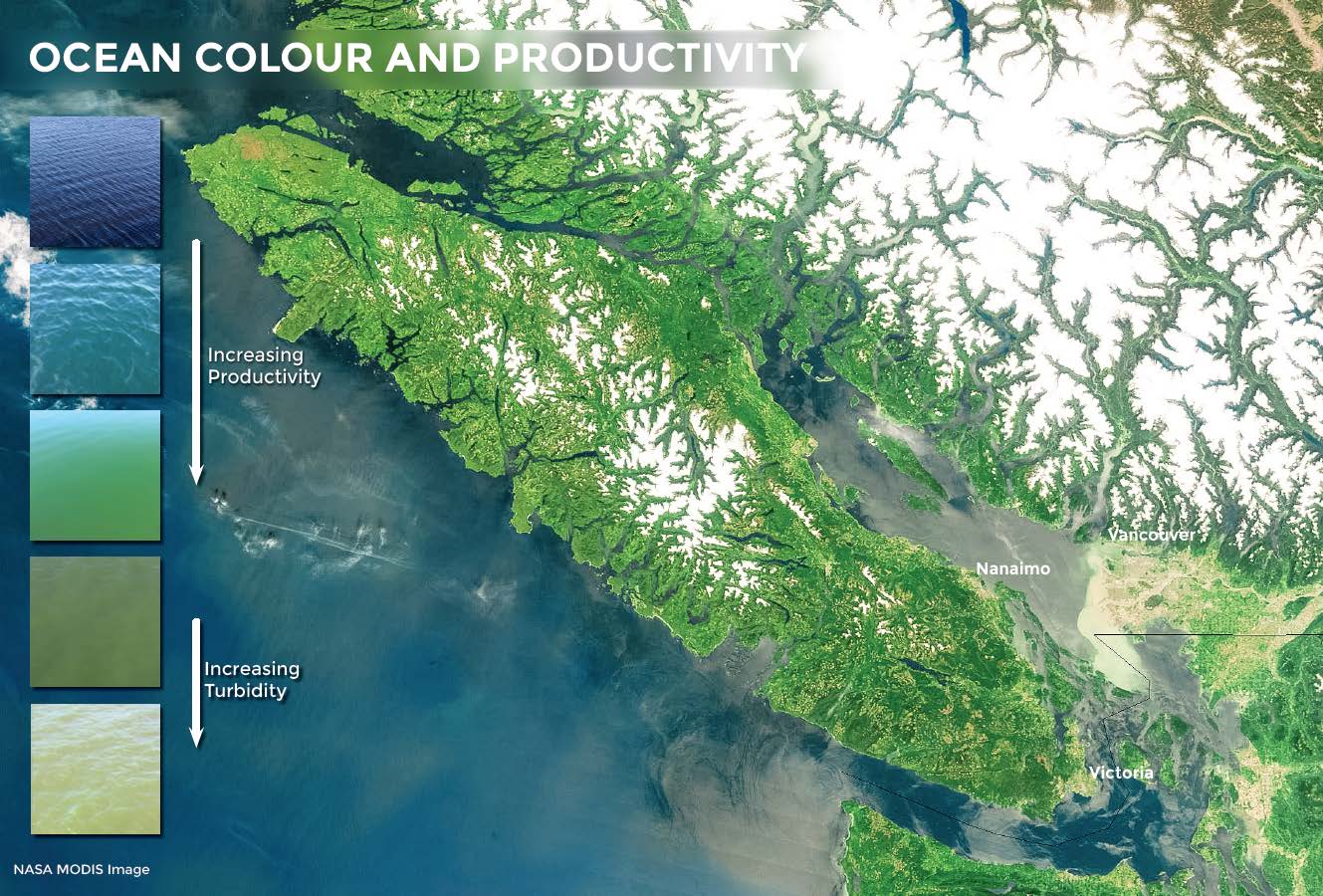
FOCOS is a new CFI/BCKDF equipment award that comprises two sets of above-water hyperspectral radiometers (HyperSAS Aiming) to measure sea surface reflectance, which are mounted on two ferries crossing optically different waters of the Salish Sea: Duke Point-Tsawwassen and Departure Bay-Horseshoe Bay (Figure 1). The sensors are positioned to avoid shadows, spray, and sun glitter, and data correction applied as required [21], and have an autonomous solar tracker system, recently developed by Satlantic, to maintain ideal geometry. FOCOS will provide water reflectance for validation of atmospheric correction of satellite images and development of reflectance-based regional models for estimating Chla.
Acquisition of accurately tested spatial-temporal environmental data using non-specialized assets, ferries, citizens, and satellites will ensure that environmental data is available at the scales required for fisheries management. Relfectance data from FOCOS will be used in conjunction with water biogeochemical properties acquired with ferryboxes on the same ferries and water reflectance and biogeochemical properties acquired by “ferry scientists” (passengers) and “fisher scientists” (fishermen) with iPads. Additionally, this data will be used to validate satellite imagery, which requires validation of atmospheric correction and development of reflectance-based regional models to derive accurate products (e.g., chlorophyll a -Chla- proxy phytoplankton biomass). With current research activities our success rate of matchup between high quality satellite imagery and ship-based measurements is < 10% due to the cloud climatology and frequency of cruises, thus delaying the advance of the use of satellite products. Activities such as those describe here will enormously increase matchups and the derivation of high quality products.
Funding provided by

In collaboration with