Spatial-Temporal Kelp Dynamics
The SPECTRAL lab is engaged in multiple projects focusing on the use of remote sensing technologies to map kelp forests on the coast of British Columbia. With multiple scientific and community partners we hope to gain a better understanding of kelp distribution, dynamics, and change by developing novel techniques for kelp detection and image analysis.
SKeMa: Satellite-based Kelp Mapping
Project Contributors: Mohsen Ghanbari, Piper Steffen
Kelp forests are among the most complex and productive ecosystems, essential to the health of coastal environments. These underwater forests play a crucial role in marine biodiversity, providing habitats for numerous species, including Pacific salmon and herring, which are both culturally and economically significant to First Nations. Beyond this, kelp forests help stabilize shorelines and contribute to carbon and nitrogen cycles. Due to threats such as climate change and coastal development, monitoring kelp forests has become more vital than ever. Satellite images, like those from the Sentinel-2 mission, enable us to efficiently observe and map these expansive kelp habitats over time, supporting First Nations' efforts to monitor and conserve these critical areas within their traditional territories.
The SKeMa project (Satellite-based Kelp Mapping) aims to develop a software tool to support kelp mapping using Sentinel-2 imagery. This tool integrates deep-learning methods, allowing us to precisely identify kelp and monitor its changes. Designed with a user-friendly interface, SKeMa will be used primarily by First Nations communities, empowering them to monitor their marine environments and make informed decisions about conservation and management. This collaborative approach not only enhances local capacity but also aligns with Canada’s broader goals for marine conservation and sustainable resource management.

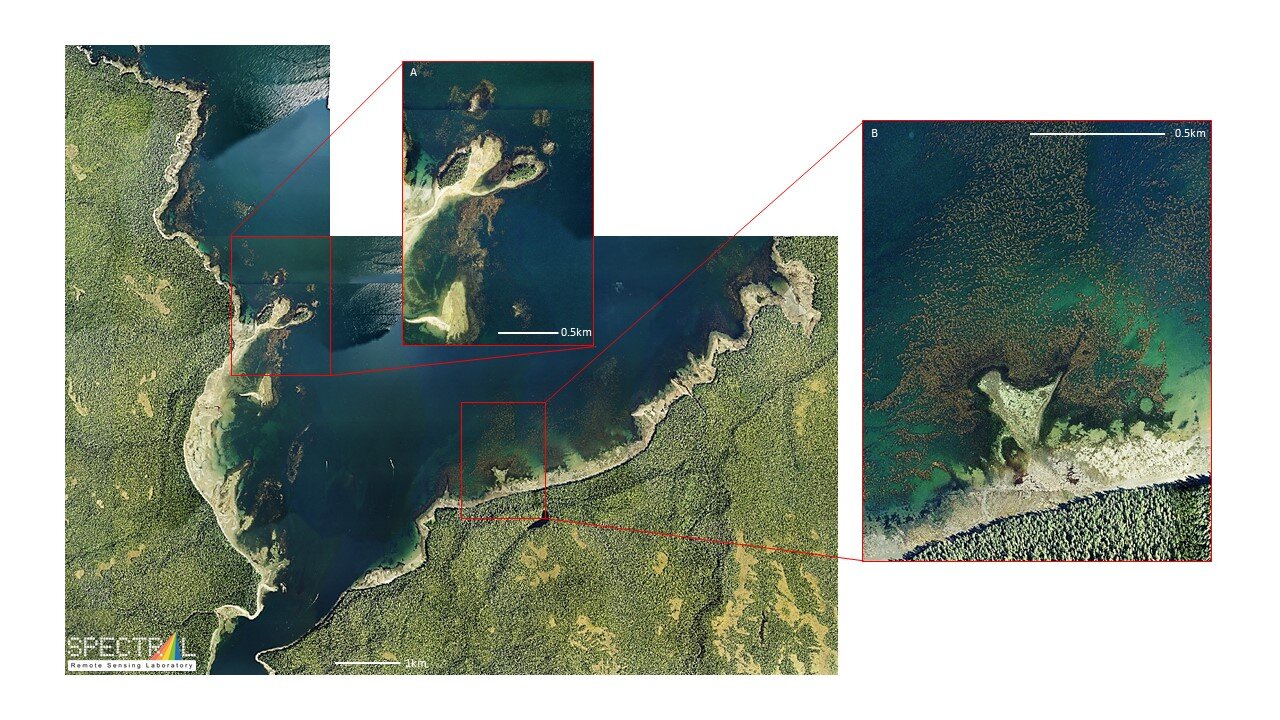
A Sentinel-2 image acquired over the northern part of Vancouver Island, BC. A subset of the image (256x256) containing floating kelp is shown in the bottom right as an RGB composite and in the upper right as a NIR-R-G composite.
NSERC Kelp Alliance: Kelp forest detection using the satellite SAR remote sensing on the British Columbia coast
Project Contributors: Marta Konik
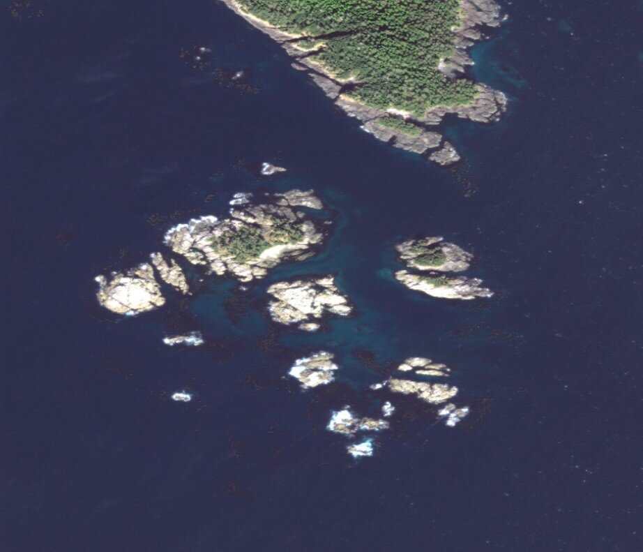
Kelp form a unique habitat sustaining biodiversity by providing refugia and foraging opportunities for animals of all trophic levels. In recent years, a decrease in kelp biomass has been observed in many regions worldwide, drawing attention to increasing environmental pressures threatening the stability of local kelp populations. Since kelp are foundation species, shifts in phenology may have cascading effects on the distribution and abundance of associated marine life. One of the reasons identified for kelp decline is increasing ocean temperatures, which is also expected to affect kelp phenology: the timing in which species grow and reproduce throughout a given season.
Thus far, kelp forests have been monitored using optical satellite, aerial, and drone imagery, but in regions like the British Columbia coast, cloud cover is a severely limiting factor. Therefore, this project focuses on developing an algorithm for mapping kelp forest extent based on the Synthetic Aperture Radar (SAR) satellite sensors, which are less impacted by the atmosphere than optical imagery. Using SAR will expand the time series and improve the detection of changes in kelp forest areal extent. Previous research showed that kelps may be detected in SAR imagery due to the leaf-like blades extending several meters over the sea surface and creating a canopy floating a few centimetres above the water level, which changes the sea surface roughness measured by SAR. Exploiting the synergy between SAR and optical data is a promising avenue for filling in the gaps in our knowledge of the local dynamics of the kelp canopies, helping issue early warnings of kelp forest extent change, and supporting kelp protection and restoration initiatives in the future.

Comparison between kelp forest extent (left) in the Sentinel-2 Level-2 MSI image taken on September 2nd, 2023 19:09:21 UTC, and (right) in the Sentinel-1A image taken on September 3rd, 2023 02:10:50 UTC, with kelp bed outlined with the yellow rectangle.
NSERC Kelp Alliance Projects
Project Contributors: Alena Wachmann, Lauren Man, Shawn Meredyk, Sarah Schroeder, Romina Barbosa
As foundation species and marine ecosystem engineers, canopy-forming giant (Macrocystis pyrifera) and bull (Nereocystis leutkeana) kelp species (herein referred to as kelps) form the basis of one of the most productive and structurally complex coastal ecosystems globally. Kelps play an important role in maintaining marine food webs, buffering shorelines against coastal erosion, and contributing to carbon and nitrogen cycling. Specifically, in the Northeast Pacific, persistent kelp forests are historically important for First Nations. The goal of the Alliance Partnership and the British Columbia Kelp Resiliency (BCKelpR) project is to determine the long-term (centennial, decadal, and annual) distribution of canopy-forming kelp forests and define spatial-temporal resilience to abiotic and biotic drivers, in the context of climate change, to aid in local and regional management strategies.
Spatial-temporal kelp resilience on the BC coast

Coverage of satellite imagery on the BC coast. (Canadian Hydrographic Service)
Project Contributors: Alejandra Mora-Soto, Alena Wachmann, Brian Timmer, Gita Nayaran, Lianna Gendell, Sarah Schroeder
Bull kelp (Nereocystis luetkeana) and giant kelp (Macrocystis pyrifera) are important canopy-forming kelp species found in marine nearshore habitats on the west coast of Canada. These kelp species form complex, three-dimensional habitat that supports a diversity of fish, invertebrates, and marine mammals. Canopy-forming kelps show high seasonal and interannual variability as their recruitment, growth, and survival are influenced by several abiotic (e.g., temperature, salinity, nutrients, light) and biotic (e.g., grazing, intraspecific competition) drivers. As a result, kelp populations are expected to change in response to shifts in underlying environmental conditions associated with climate change. They may also shift in response to changes in the biotic community (e.g., sea otter recovery, sea star wasting disease) or human activities (e.g., sea urchin harvest, kelp harvest). Traditionally, kelp ecology has focused on individual research sites or regions encompassing a gradient of climate or biological drivers. We aim to quantify kelp resilience to changing conditions across a larger scale - focusing on the British Columbia coast - encompassing overlapping gradients at an appropriate scale to tease apart biological and climate drivers.
The focus of the research is to quantify kelp resilience to changing conditions across the British Columbia coast, encompassing overlapping gradients at an appropriate scale to tease apart biological and climate drivers. The research is expected to address the following:
I. Define spatiotemporal kelp resilience. Develop a spatiotemporal map of kelp extent based on (a) Contemporary (2005 to present) satellite data; (b) Intermediate (70s to 90s) data from large-scale coastal kelp inventories, as well as archived government data and coarse resolution satellite imagery; and (c) Available historical (1850-1950) spatial data based on British Admiralty Charts.
II. Define the environmental and biological drivers of kelp change. Examine how environmental gradients in temperature and other climate drivers influence the spatiotemporal extent of kelp. From this analysis, we will determine the status of this critical habitat and its capacity for resilience (resistance and recovery).


Kelp forest distribution and drivers of change in Haida Gwaii, British Columbia

Project Contributors: Lianna Gendall, Shawn Meredyk
The kelp forests of Haida Gwaii are important areas of ecological value that support numerous cultural and commercial fisheries such as Pacific halibut, sablefish, numerous species of rockfish, sole, cod, Pacific herring including roe-on-kelp, red sea urchin and the endangered Northern abalone. However, long-term monitoring of the kelp forests in the Haida Gwaii region is at its inception and drivers of change are poorly understood. This project aims to fill this gap, and contribute to future stewardship of kelp habitats in the marine waters of Haida Gwaii.
The main goal of this research is to quantify the distribution and variability of the kelp forests of Haida Gwaii, British Columbia, as well as the relationship between kelp forests and environmental drivers of change.
In order to accomplish this goal:
1) high-resolution satellite imagery will be used to create a 21st century baseline map of kelp forests for comparison with historic data, from British Admiralty Nautical Charts (1856-1958), Provincial aerial surveys (1973, 1976) and ShoreZone surveys (1991-2,1996).
2) the spatiotemporal trends in kelp forests persistence will be quantified using a spatial subset of high-temporal resolution data including satellite imagery and historic surveys to understand the relationship between kelp forest persistence and drivers of change.
In particular, this project fits into the Spectral Remote Sensing Lab’s Kelp Resiliency Research Program in collaboration with the kelp monitoring initiative led by the Marine Plan Partnership for the North Pacific Coast (MaPP) and the Hakai Institute (Margot Hessing-Lewis, Luba Reshitnyk). The results of this study will lend insight into the responses of kelp forests to drivers of change in Haida Gwaii and provide an accurate baseline that will further enable management. These baselines will inform the implementation of ecosystem-based monitoring in Haida Gwaii (as prescribed by the Haida Gwaii Marine Plan), the management of kelp harvests, (which are reviewed by the Council of the Haida Nation Marine Planning group), and the restoration of kelp forest ecosystems (Chiixuu Tll iinasdll: Nurturing Seafood to Grow; Parks Canada project in collaboration with Haida Fisheries). More broadly, this research will contribute to a framework for how to compile and combine historic data with satellite imagery to produce usable datasets for managers and academics.
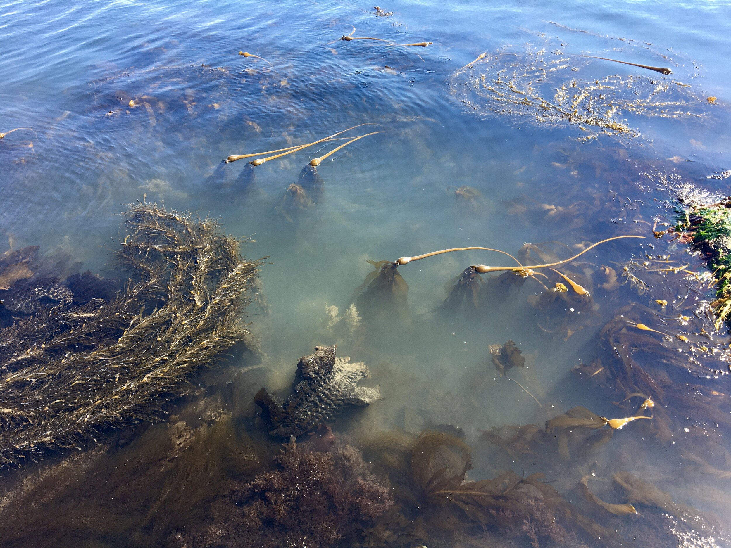

The effects of tides and currents on the remote sensing of kelp forests
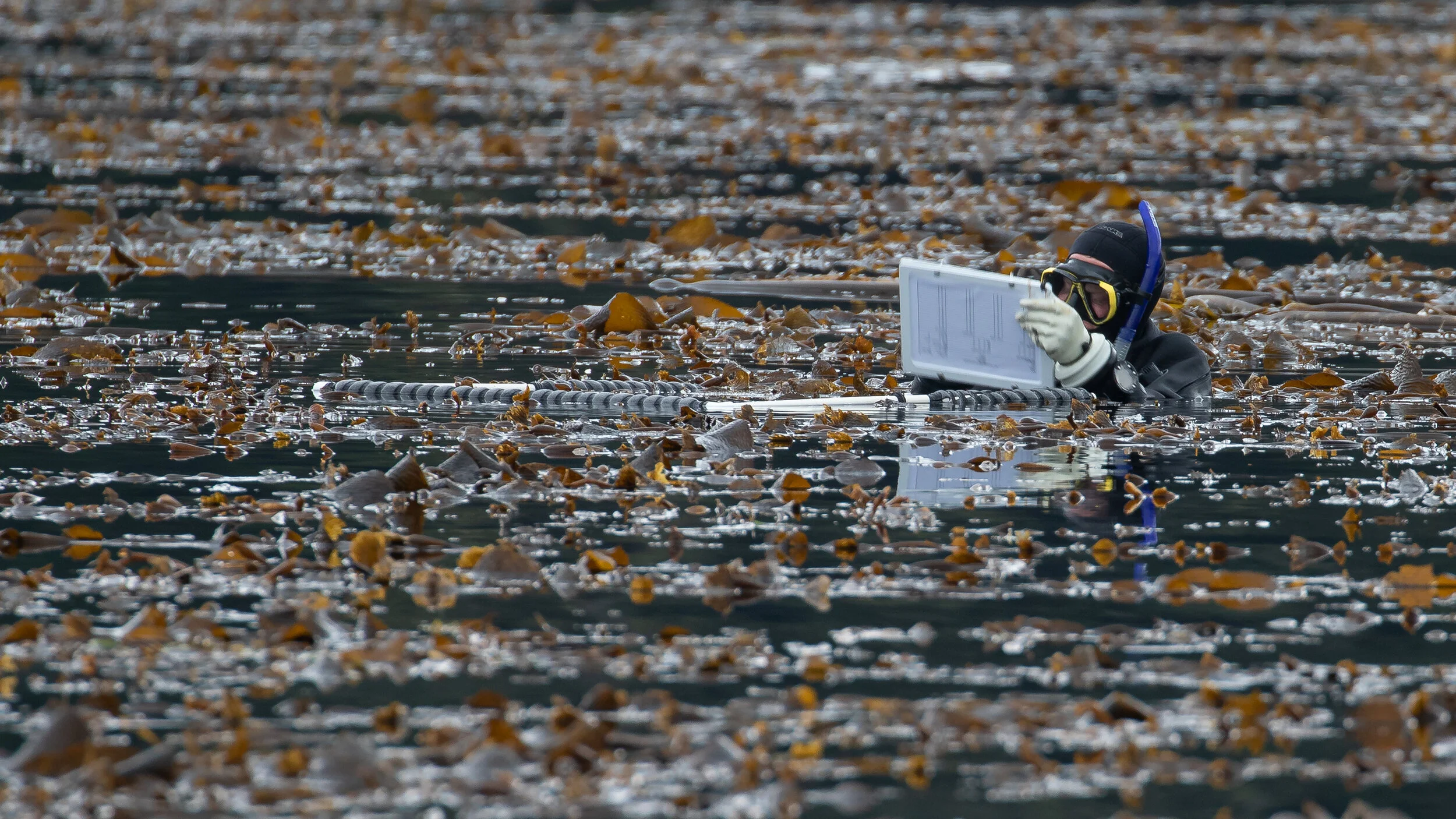
Brain Timmer of UVic Spectral Lab sampling in kelp beds on the BC coast. Credit: Markus Thompson
About this Project:
Project Contributors: Brian Timmer
When surveying kelp with remote sensing techniques, oceanographic factors such as tidal height and currents can affect how kelp is sensed from different platforms. In an effort to better understand how tides and currents affect the remote sensing of kelp forests, the UVic Spectral lab is working in close collaboration with the Hakai Geospatial team around Calvert Island on the Central Coast of British Columbia. This project will include the collection of in situ hyperspectral data to be paired with multispectral Remotely Piloted Aerial System (RPAS) and Earth Observation Satellite (EOS) imagery. By surveying kelp forests over multiple tidal heights and conducting controlled kelp submergence experiments, Brian will investigate the uncertainties associated with area and density metrics derived from the collection of remote sensing imagery under different tide/current conditions.

Historical distribution of kelp forests on the coast of British Columbia: 1858–1956

About this Project:
The quantification of kelp forest distribution across space and time is critical to support decision-makers responsible for habitat management and conservation. Spatial data such as aerial photos and satellite imagery are key for deriving kelp distribution; however, they have only become available at an adequate quality within the 20th and 21st centuries. In this study, British Admiralty (BA) charts created between 1858 and 1956 covering the British Columbia coast and portions of the adjacent Washington and Alaska coast were used to create a digital historical baseline map of kelp presence. A total of 137 BA charts were scanned at 200 DPI, georeferenced, and kelp features were manually digitized following a rigorous method considering the scale and quality of the data. An accuracy assessment of the digitized kelp features concluded that 99% of the kelp features occurred in expected areas within a depth of less than 40 m, and only about 1% of the features occurred entirely outside of this depth. Recently mapped kelp forests in similar areas reaffirmed the results of the produced baseline map. Potential sources of uncertainty should be considered when working with the historic BA charts such as the surveyor's method for defining floating kelp features, the artistic ability of the cartographer when transcribing the information from the surveys to the BA charts, and the regional seasonality of kelp cover. The outcome of this research shows that the historical BA charts are an unconventional but extremely rich source of baseline coastal habitat data from the 19th century. The methods conducted are simple and robust and could be applied to other regions where historical charts with sufficient quality exist. Link to publication.
The digitized kelp polygons are available to download here.
